")
Remembering our Past: Fort Frances, Minnesota, or International Falls, Ontario? The 1910 border dispute
When surveyors drew the boundary between Canada and the United States, the line through most of northwestern Ontario was one area that was agreed upon without much dispute.
The border along Ontario/Minnesota from Lake Superior to Lake of the Woods was first determined in the Treaty of Paris between Great Britain and the United States, reached in 1783, which signalled an end to the American Revolution.
This line was reconfirmed in the subsequent Treaties, including the 1908 Treaty that led to the creation of the International Joint Commission.
“It being mutually understood that the boundary, so far as practicable, shall be a water line and shall not intersect islands lying along its course, and the Commissioners shall, so far as practicable, mark such boundary along its course by monuments and buoys and range marks,” states the Treaty.
This agreement was tested in October 1910 when claims were made that the border was wrongly placed.
It was initiated by a story published in the International Falls Press that indicated “agents” with the U.S. Department of Justice discovered documents, noting the border was situated further north of the Rainy River because Canada forfeited land along the river to the U.S.
A survey dating to 1849 was brought forward as evidence.
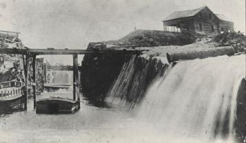
The forfeiture was said to be connected to an agreement made in the late 1860s, in which the Canadian government committed to building a canal linking Rainy Lake and Rainy River, allowing vessels to avoid the Koochiching Rapids.
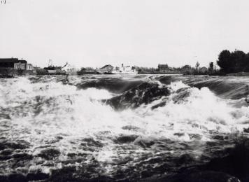
Rainy River, at the time, was an active shipping route, and the Americans claimed the canal was to run through a portion of what is now Point Park and come about 600 yards west of the rapids.
This meant that portions of downtown Fort Frances were occupying U.S. land.
American authorities claimed Canada started the project, then stopped due to the Fenian Raids, conducted by Irish nationalists from the U.S. who unsuccessfully attempted to conquer Canada in a bid to gain independence.
When the threat was quelled, Canada is said to have abandoned the canal.
Construction started in 1876 with the excavation of the 800-foot section where a lock would be situated.
Much of the work was completed within two years but came to a halt following the election of Sir John A. McDonald and his Conservative Party in October 1878.
McDonald supported a national railway to move people and goods across the country instead of an “amphibious route” that was promoted by the previous Liberal government under Alexander MacKenzie.
The canal proposal was renewed in 1910, with federal legislation proposing the creation of the Western Canal Company.
Mayor David Croal McKenzie and area businessmen George Archibald Stethen, Herbert Williams, and Octave Jalbert were among those listed as shareholders.
Their project was more ambitious and lengthy, going from a location on Rainy Lake, five miles east of Fort Frances, to west of the Long Sault rapids on Rainy Lake.
The bill was defeated in the House of Commons because MPs thought it was too large and costly an undertaking.
Not long after the bill’s defeat, R. J. Patrick, an agent from the U.S. Department of Justice, arrived in International Falls to see if any work was taking place.
Others were spotted on Rainy Lake trying to determine if Canadians were fishing on the American side of the lake.
The news of the border’s changed location was met with skepticism in Fort Frances.
“It is surprising to know how many people really swallowed this incredulous yarn,” wrote Joseph Alexander Osborne, the Editor and Founder of the Fort Frances Times, and town councillor.
“Fort Frances is in Canada and will always remain on this side of the boundary line unless the two nations should some day be amalgamated.”
Mayor Herbert Williams offered little comment, but was reported to be moving his fur traps further inland as a precaution.
Members of the Fort Frances Police Department also began patrolling the shoreline to watch for American citizens who may be attempting to enter Canada illegally.
Northern Minnesota was also dealing with severe forest fires and had troops sent to the area to assist.
When they attempted to cross into Canada to reach the Baudette area, they were denied by customs officials who worried their presence was for ulterior reasons.
While neither government came out with an official stance, the editor of the International Press took to calling Fort Frances “North International Falls” in subsequent stories.
The newspapers also indicated that City Marshal Thomas White was dispatched to Fort Frances to place U.S. flags at key landmarks said to be situated on U.S. land. This includes the post office, customs office, Canadian Imperial Bank of Commerce, and other businesses in the new downtown core that flourished since the 1905 fire devastated much of the former business centre along Front Street.
The dispute confused travellers at the border who objected to paying duties if officials thought the line was not where it should be located.
Fingers were quickly pointed at Edward Wellington Backus for being behind the border flap.
He had signed an agreement to provide power to Fort Frances from a new dam at Koochiching Falls, but the price for that power was not yet finalized. Some suggested that moving the border would negate the agreement.
Backus, who was at Kettle Falls when the news broke, was approached by a reporter from the International Falls Press about the issue and the allegations levelled against him.
“This is the first I have heard of this, and I can not believe it was true,” insisted Backus.
A Canadian land commissioner lent some credibility to the story.
John Meyer stated that when American and Canadian engineers and land surveyors had plotted two boundaries to the first island below Koochiching Falls.
Meyer confirmed one linked to an island on Rainy Lake where the group had paddled to portage past the falls, suggesting a straight line would be less confusing than measuring a meandering one along the river.
This, however, contravened the idea of an all-water boundary recommended in the treaty.
The International Falls Press made no mention of the second boundary route, leaving readers with the impression that it was the current boundary that followed the river.
Canadians doing their own research unveiled an 1858 survey that outlined an alternate boundary line that started at the Little Fork River, going easterly to Cranberry Marsh on Rainy Lake, then connecting with Kettle Falls.
Cranberry Marsh was believed to be the spot where surveyors had paddled and opted for a straight line border that Meyers had spoke of.
This would put International Falls, Rainer and all areas 14 miles to the south under Canadian ownership.
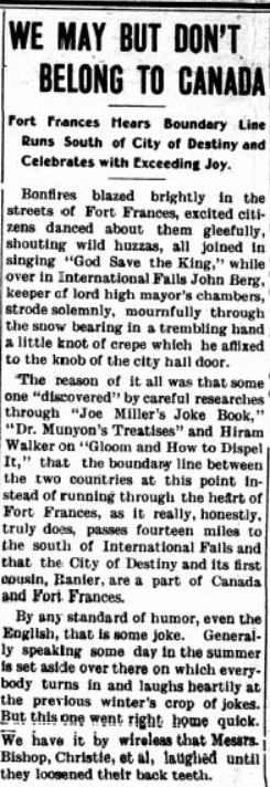
“We invite Bros. Morrison, the versatile editor of The Press, over to get acquainted with Andrew Usher, Joe Seagram, Hiram Walker, Jim Paul and other noted Canadians,” wrote the Fort Frances Times.
The Press responded with an article that was buried on the last page of the December 1st edition, mocking the discovery.
“By any standard of humor, even the English, that is some kind of joke,” wrote The Press.
No more was said about the border that remained unchanged or disputed.
Any tensions between the two communities eventually eased.
Remnants of the canal were incorporated in the dam.
Fort Frances and International Falls become sister cities 90 years later, with Canadian and American flags flown on both sides of the border, in friendship.


