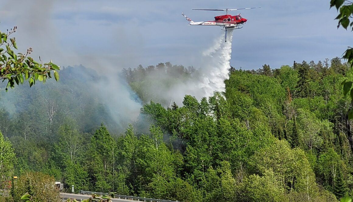
The Ministry of Natural Resources says a fire burning in the southern end of Quetico Park is no longer a public safety concern.
The fire, which originated near Agnes Lake on July 20th, has consumed 25,279 hectares and remains not under control.
It also burned into Minnesota.
The fire, though, has not grown in several days.
As a result, an evacuation alert issued for the Saganaga Lake area along the Ontario-Minnesota border has been lifted.
The area is a popular spot for canoeists using the all-water route from Lake Superior to Lake of the Woods.
Restrictions remain in place for other fires in the area.
Map showing location of Fort Frances 13, a wildland fire burning at the southern end of Quetico Provincial Park, August 6, 2026. Ministry of Natural Resources Forest Fire info map screen shot
First Nations leaders whose communities were impacted by wildland fires continue to push for a public inquiry.
They gathered in Toronto for a media conference, hours after Ministers Mike Harris, Jill Dunlop and Greg Rickford provided an update on the fire situation in northern Ontario.
Fourteen communities, mostly First Nations, had to evacuate because of threatening fires.
Many did so without assistance from the government, requiring the communities to arrange for their own transportation, temporary accommodations and other supports.
Mishkeegogamang Chief Merle Loon says there is no reason for how the government responded.
“The fact is it was too late. Too little too late,” says Loon.
“The issue is they were not prepared and ready to act. This is a systemic issue, and we need to do better in the future.”
The First Nation leaders point to government policy changes, cutbacks, and inadequate forestry management for creating the conditions that allowed some of the fires to spread rapidly.
Cat Lake First Nation Chief Russell Wesley says the inquiry is not just important for First Nations wanting answers to this year’s fire season.
Russell Wesley, Chief of Cat Lake First Nation, July 30, 2026. Livestream screen shot
“It’s just not First Nations that deserve an inquiry. It’s municipalities, little towns, and we don’t know the potential impacts of this wildfire season until we actually examine every part of it,” says Wesley.
Nishnawbe Aski Nation outlines a dozen recommendations it feels could improve the response in the future.
They include creating a First Nations wildfire authority, permanent wildfire preparedness funding, developing a First Nation-specific climate adaptation strategy to recognize changes to the fire season, and early warning systems to spot and track fires sooner.
The lack of communication between the First Nations and government is also still a concern.
Some First Nation leaders say that they still have not heard from the Premier or other cabinet members since their communities were evacuated.
Former Neskantaga Chief Wayne Moonias says that even with their residents in southern Ontario, the communication with the Premier or members of cabinet has been silent.
Wayne Moonias, former Chief of Neskantaga First Nation, July 30, 2026. Livestream screen shot
“The fact that my Chief was here with his community members for over a week, he did not get a single indication from the minister, from the government, if they were going to come and see him,” says Moonias.
“That to me is intentional. It’s a lack of respect to our First Nation when it comes to treaty partnership, meaningful partnership, partnership that can help our people, regardless where you live.”
“It appears to be a second-tiered approach to First Nation concerns as it relates to fire and evacuations,” adds Wesley.
There are still more than 2,000 people living in temporary accommodations because of the wildland fires burning in northwestern Ontario.
Fourteen communities were evacuated, many of which are First Nations.
Emergency Preparedness Minister Jill Dunlop says five have since been allowed to return home.
She says residents from another community are preparing to return in the coming days.
“Approximately 2,014 people remain evacuated to host communities across the province,” says Dunlop.
“I want to thank those host communities for raising their hand and welcoming evacuees to ensure they have the essentials that they need.”
There are still more than 110 active fires in northwestern Ontario.
There were three new fires reported on Wednesday, all small in size.
The blazes were located approximately 7 kilometres west of Highway 599 between Paguchi Lake and Victory Lake, near the north shore of Clytie Bay in Shoal Lake and in Lac Seul First Nation, between English River and Upper Grassy Bay.
Cool, wet weather is helping Ministry of Natural Resources wildland firefighters get the upper hand with suppression efforts.
Natural Resources Minister Mike Harris says over 80 have been extinguished in the last two weeks.
“There has been minimal growth on some of the more challenging fires in the northwest, like the largest fire that we’ve seen, which is Thunder Bay 36,” says Harris.
“The crews have made progress in constructing fire guards and doing values protection on this fire, like setting up sprinkler systems. In the Atikokan cluster near Quetico Park, we’re making good progress in containing those fires as well.”
Ontario continues to receive help from other provinces.
Prince Edward Island deployed ten firefighters, while Newfoundland/Labrador provided two support staff.
Alberta sent five more wildland fire specialists, increasing the support it previously committed.
New Brunswick also shipped 75 pumps for use along the fire lines.
Ontario now has 259 firefighters and 36 support personnel from outside the province working alongside MNR Fire Rangers, including 104 Mexican firefighters and support staff that arrived this week.
“One hundred and fifty-six Ontario fire crews are on the ground supported by over 140 aircraft, including 85 suppression helicopters and water bombers across the province of Ontario,” adds Harris.
Four waterbombers, five helicopters and three support aircraft from other provinces are also being utilized.
Another evacuation order has been issued because of threatening wildland fires.
The fire is burning east of the Turtle River-White Otter Lake Provincial Park and into the Campus Lake Conservation Reserve, about 20 kilometres south of Ignace.
The Ministry lists the fire as scorching about 1,800 hectares and not under control.
It was first reported in the middle of July.
The Ministry is now telling people who may be residing or using the area to evacuate.
An Implementation Order has also been imposed for the same area.
This restricts public access to the area while fire crews tackle the blaze.
The Chiefs of First Nations communities impacted by forest fires in northwestern Ontario want a public inquiry to examine the province’s response and how prepared it was for the fire season.
They feel that First Nations were left on their own when it came to evacuating.
Gull Bay Chief Wilfred King points blame at the decisions made at the senior leadership level.
“The Chiefs’ concern is directed at executive leadership and decision-making rather than operational personnel,” says King.
“The review should examine operational decision-making, emergency coordination, communications with First Nations, evacuation planning and execution, resource allocation, and overall provincial preparedness.”
Whitewater Lake First Nation is among eight First Nations that have faced evacuations.
Whitesand First Nation Chief Lawrence Wanakamik says they made the call to leave because the MNR was too slow to recognize the danger impacting his community.
“Whitesand’s own preparation and decision-making helped prevent an already dangerous situation from becoming worse,” says Wanakamik.
He says they were forced to transport, feed, and support residents, as well as those from Armstrong, because the supports were not in place.
Nishnawbe Aski Nations Grand Chief Adam Fiddler says the communities did the best they could with the information that was made available to them.
He says the poor response and lack of communication from the province is unacceptable.
“It’s quite clear that moving forward, the jurisdictional barriers need to come down,” says Fiddler.
“Our community leadership needs to be at the table where those vital decisions are made. Those decisions we heard the chief talk about, a couple of days ahead, they were not told. Somebody knew, but that information wasn’t being shared.”
King says the entire emergency management system needs a complete overhaul that includes the involvement of First Nations.
“We can’t be an afterthought. We have to be there at the table to structure these responses where First Nations are, at least, given the authority in terms of expenditures and that sort of thing.”
Fiddler notes that a proposal was given to the Premier several years ago but unacknowledged.
The Chiefs add that since their communities have been evacuated, none have received any calls from the Premier, Indigenous Affairs Minister Greg Rickford or Minister of Natural Resources Mike Harris.
Eabametoong First Nation Chief Sol Atlookan goes as far as suggesting that Rickford should resign.
“I think he doesn’t even know his job description,” says Atlookan.
“Why is he called Minister of Indigenous Affairs? Shouldn’t he be the first to jump up and get his people organized to tackle the danger of the forest fires? I, for one, say, Minister Rickford, I think it’s about time you stepped down.”
Acadia News has reached out to Rickford for comment.
King says he had a brief but terse conversation with Ford on the weekend, when he stumbled upon the Premier when he visited the evacuation centre in Thunder Bay.
Tammy Butler, who lives near the Mooseland wildfire, says it was “heartbreaking” to leave the home she and her husband worked hard to build when an evacuation order forced them out Thursday night.
After spending days wondering what she might return to, Butler says she was relieved to learn that Nova Scotia Emergency Management had lifted the evacuation order on Sunday morning, and that residents could head home.
The Department of Natural Resources (DNR) declared the wildfire held at 1,447 hectares around 10:30 a.m., but cautioned evacuees to remain prepared in case conditions change.
As of 3:30 on Sunday afternoon, DNR says that crews are still actively responding near Sixth Lake in Halifax County, and that aircraft are on standby but not anticipated to be needed.
From the first alert
Butler explains that it wasn’t long after getting home from work on Wednesday that her and her husband noticed something wasn’t right.
“It was probably about four or five o’clock and we heard sirens, and then a lot of sirens, and being in a small community when fire trucks go by like that, you know it’s not good.”
Butler says they waited for a while and then found out that there was a forest fire nearby.
“We went to bed that night and got up the next day, carried on our business.”
She says even though her and her husband knew things were bad, they didn’t exactly know how bad.
“Thursday, probably around four o’clock or so, we could see a large amount of smoke above our home and got worried, of course, and then we got the alert.”
The alert caused instant panic, she says, and even though the fire was quite a distance away, she wanted to be as prepared as possible.
It was around eight o’clock Thursday night when she had to gather her family and leave on short notice.
“There was a previous alert for civic numbers further away from us.” Then another alert came in.
“My husband said, ‘That’s us, we gotta go.'”
Tammy Butler’s house at Third Lake near the Mooseland Wildfire. PHOTO: TAMMY BUTLER
Butler says they were fortunate to have a safe place to stay. At the time, two Red Cross evacuation centres were activated for anyone needing somewhere to go, and have since been closed.
“We have a lot of family and a lot of friends that have offered us a place to stay. We’re currently staying at my daughter and son-in-law’s, and they’ve been wonderful,” explains Butler, but says she’s worried about her home.
“It’s a fishing camp that we bought on Third Lake, and we renovated the whole thing and have made it into a beautiful, beautiful home.”
Butler and her husband were two of around 150 people evacuated from the area on Thursday night.
She says it was a heartbreaking decision to leave their home.
“My husband’s done 90% of the work, and we had to walk away and hope that when we get back, it’s there. Yes, we have insurance, but to replace that in a new build is not the same. So, we’re hoping the firefighters can look after it, and we’re back in our home very soon.”
Butler and her husband were relieved to return home safely on Sunday.
So far this year, Nova Scotia has seen around 100 wildfires reported across the province, which is more than double the number we had this time last year, says Minister of Natural Resources, Tory Rushton.
During wildfire risk season, there is no domestic brush burning or campfires allowed between 8 a.m. and 2 p.m., and Rushton wants to remind people to always check the most current restrictions before burning.
The fine for not following these rules is $25,000, and Rushton emphasizes that they are “in place to protect people, communities, and our natural resources.”
Rushton mentions that most wildfires are caused by people, meaning that many are preventable. He wants people to be cautious when having a fire of any kind, including disposing cigarettes or cannabis products.
The public is asked to report any wildfire or person violating burn restrictions.
A mandatory evacuation order, also called an Emergency Area Order (EAO), has been issued for an area south of Lac de Mille Lacs to Highway 11 as the Fort Frances 14 wildfire continues to burn out of control.
The area is contained within Windigoostigwan Lake Road, Brule Road, Lily Lake Road, and Chief Peter Lake Road.
The Ministry of Natural Resources has put special emergency restrictions in place around the fire to keep people safe and give firefighters room to work. The order limits access to affected roads, waterways, and Crown land near the fire.
The EOA took effect at 7 a.m. on July 17 and will remain in place until further notice.
At more than 55,000 hectares, this fire is burning between Highway 17 and Highway 11, with its closest point about five kilometres south of the Trans-Canada Highway.
The Ontario Ministry of Natural Resources (MNR) says all people within the designated evacuation zone must leave immediately unless authorized through a travel permit issued by the ministry. Entry into the evacuation area is also prohibited without authorization.
There is also a Notice to Airmen (NOTAM) issued in the area of the Fort Frances 14 wildfire. Pilots are being told to stay away from the area because firefighting aircraft need the airspace to operate safely.
Authorities are reminding pilots that NOTAMs concerning forest fires can be found on NavCanada’s Collaborative Flight Planning Services under the ‘Weather and NOTAM’ tab, when flight planning.
An evacuation order for the Mooseland Road wildfire has prompted emergency crews to remind residents what they need to pack in case they have to leave their homes on short notice.
Halifax Professional Fire Fighters say several essential items should be included in a go-bag so residents can be prepared to evacuate if conditions change.
Some recommended go-bag items include:
Medications for at least seven days
Extra clothing and personal hygiene items
Flashlights, chargers, and batteries
Non-perishable food, such as protein bars and trail mix
Bottled water
A first aid kit, multi-tool, and whistle
Cash
Important documents, including identification, insurance information, and emergency contact details
A portable hand-crank radio
Pet food
As of 8:28 p.m. Thursday night, the Mooseland Road Wildfire has expanded and an evacuation order was issued by public safety officials for civic addresses from 4315 Mooseland Road down to Highway 7, according to Emergency Info Nova Scotia.
The Dartmouth SPCA made a post on social media offering help to anyone with pets who is impacted by the fire.
Two communities in northwestern Ontario are being evacuated because of the threat of forest fires, while another is being placed on alert.
Provincial Police states that mandatory evacuation orders have been issued for residents of Armstrong and nearby Whitesand First Nation.
Several fires are burning nearby, bringing smoke into the two communities.
The largest of the blazes has been burning near Collins since the end of May and has blackened more than 14,000 hectares.
Emergency crews are in communities to assist with the evacuations.
In the meantime, Ignace is being monitored for what the OPP call an evolving situation.
No other details were provided.
The Ministry of Natural Resources says 31 new wildland fires were reported on Monday.
They include
Fort Frances 38 (FOR038) is located north of Hwy. 11 near Duck Lake, approximately 26 kilometres east of Atikokan. The 5.0-hectare fire received air attack on July 13 and is not under control.
Fort Frances 37 (FOR037) is located north of Crooked Lake in Quetico Provincial Park, approximately 61 kilometres south of Atikokan. The 5-hectare fire is being observed.
Fort Frances 36 (FOR036) is located near French Lake, approximately 36 kilometres east of Atikokan. The 0.2-hectare fire is being held.
Sioux Lookout 89 (SLK089) is located near Hill Lake, approximately 19 kilometres north of the Ojibway Nation of Saugeen. The fire is not under control at 55 hectares.
Sioux Lookout 88 (SLK088) is located near Doghole Lake, approximately 8 kilometres southwest of Mishkeegogamang First Nation. The fire is not under control at 0.2 hectares.
Sioux Lookout 87 (SLK 087) is located on an island on Lake of Bays, approximately 40 kilometres southeast of Sioux Lookout. The fire is not under control at 0.2 hectares.
Sioux Lookout 86 (300 hectares) and Sioux Lookout 85 (0.3 hectares) are located near Pashkokogan Lake, approximately 18 and 22 kilometres south of Mishkeegogamang First Nation, respectively.
Sioux Lookout 84 (SLK084) is located near DeLesseps Lake, approximately 71 kilometres south of Mishkeegogamang First Nation. The 143-hectare fire is not under control.
Dryden 36 (DRY036) is located near Lower Moosehide Lake, approximately 21 kilometres southwest of Ignace. The fire is not under control at 60 hectares.
Dryden 35 (DRY035) is located near Weaver Lake, approximately 72 kilometres north of Upsala. The fire is not under control at 500 hectares.
Dryden 34 (DRY034) is located near Harmon Lake, approximately 28 kilometres south of the Allanwater Bridge. The fire is not under control at 400 hectares.
Dryden 33 (DRY033) is located on a southern peninsula of Eagle Lake, approximately 11 kilometres southwest of Migisi Sahgaigan First Nation. The fire is not under control at 3 hectares.
Dryden 32 (DRY032) was located adjacent to Hwy. 647 near Blue Lake Provincial Park. The fire was called out at 0.1 hectares.
Thunder Bay 59 (THU059) is located near the northern shore of Lake Nipigon, approximately 35 kilometres east of Armstrong. The fire is not under control at 0.2 hectares.
Thunder Bay 58 (THU058) is located approximately 2 kilometres south of Pallisades Rd. near the junction of Moore Rd. The 1.0 hectare fire received air attack from waterbombers this afternoon. The fire is not under control.
Thunder Bay 57 (THU 057) is located approximately 5.5 kilometres north of Whitefish Lake. The fire is not under control at 0.5 hectares.
Thunder Bay 56 (THU056) is located near Wawang Lake, approximately 41 kilometres north of Upsala. The 400-hectare fire is not under control.
Thunder Bay 55 (THU055) is located near Smoothrock Lake in Wabakimi Provincial Park, approximately 37 kilometres northwest of Armstrong. The fire is not under control at 5 hectares.
Thunder Bay 54 (THU 054) is located near Brett Lake, approximately 59 kilometres west of Gull River First Nation. The 400-hectare fire is not under control.
Thunder Bay 53 (1.0 hectare), Thunder Bay 50 (25 hectares) and Thunder Bay 49 (0.1 hectare) are located west of Caribou Lake in Wabakimi Provincial Park, approximately 21 kilometres north of Armstrong.
Thunder Bay 52 (THU052) is located east of Wabakimi Provincial Park, approximately 37 kilometres north of Armstrong. The fire is not under control at 0.1 hectares.
Thunder Bay 51 (THU 051) is located approximately 6.3 kilometres northwest of Whitefish Lake. The 9.0-hectare fire received air attack from waterbombers on July 13. The fire remains not under control.
Nipigon 40 (NIP040) is located near Opichaun Lake, approximately 42 kilometres south of Fort Hope First Nation. The 1.0-hectare fire is not under control.
Nipigon 39 (0.5 hectares) and Nipigon 38 (1.5 hectares) are located near Sollas Lake, approximately 38 kilometres northwest of Aroland. Both fires are not under control.
Nipigon 37 (NIP037) is located south of Toronto Lake, approximately 61 kilometres west of Aroland. The 35-hectare fire is not under control.
Nipigon 36 (NIP036) is located near the north shore of Miminiska Lake, approximately 56 kilometres west of Fort Hope First Nation.
Nipigon 35 (NIP035) is located south of Luella Lake, approximately 72 kilometres southwest of Fort Hope First Nation. The 150-hectare fire is being observed.
As of Tuesday morning, 128 fires were active across northwestern Ontario.
Fifty-three are considered not under control, with the MNR watching closely 63 fires, but taking no immediate action to put them out as they are posing no threat to the public or property.